The idea that warming has to lead to more severe weather is directly challenged by the cold hard facts on tornadoes
If we look at the charts of strongest tornadoes, as the earth has warmed, strong to severe tornadoes have dropped, The chart is clear.
.png)
The reason for this is intuitive; Strong to Severe tornadoes develop in the times of greatest clashes between cold and warm, When its colder in the US, it focuses the clash zone closer to areas that are going to be warm and moist in May, So there is a ready clash,
When we look at tornadoes this year, we find its above average.
.png)

2008 and 2011 stand out like sore thumbs and of course, when they occurred they were being touted as the new normal.
There is a subtle difference between this year and the two mega years, and it is over Texas, Because of all the heavy rain, this spring has been a bit cooler in Texas
.png)
 It is interesting to note the recent highest risk day was centered in the Texas Panhandle yet did not produce the number of tornadoes we saw further east. As it gets later in the season, even if it is cool in Texas it is still warmer overall than it was, and if the cold keeps fighting, the severe weather increases, until later In June and beyond when the warmth is more uniform and cold air masses are much weaker in 2008 and 2011. Texas was warm, but there was loads of cold air on the weather map. But you can see source regions were at the ready for the problem.
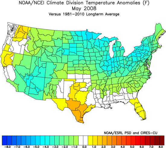
.png)
 Now look at the years when there is less than average activity.
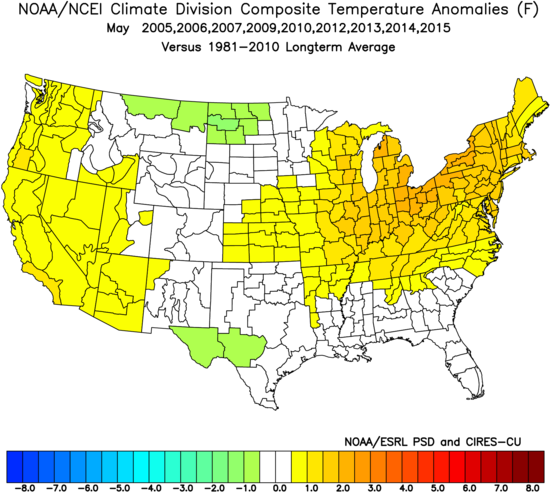
Modeling has had a tough time holding on to cold air, Both the CFSV2 and the European models from a month out had a warm over cool temperatures pattern for the U.S.
.gif)

.png)
It also means more evaporation where it is sunny much of the time over the tropics, and an increase in WV which then is taken into the Mid-latitudes and if there is not the warming leads to more precipitation. So there are some natural explanations for what we see, What there is no doubt about is a warmer US would likely be one with LESS, not more, strong tornadoes and that is demonstrated by what we are seeing right now and the charts above It also means this is not a global warming rout, that there is a fightback occurring in line with natural climate cycle theory, But then again you would have to know about the past and know about that theory to understand to suspect there is merit to saying what drove the climate and weather before is still driving it now.