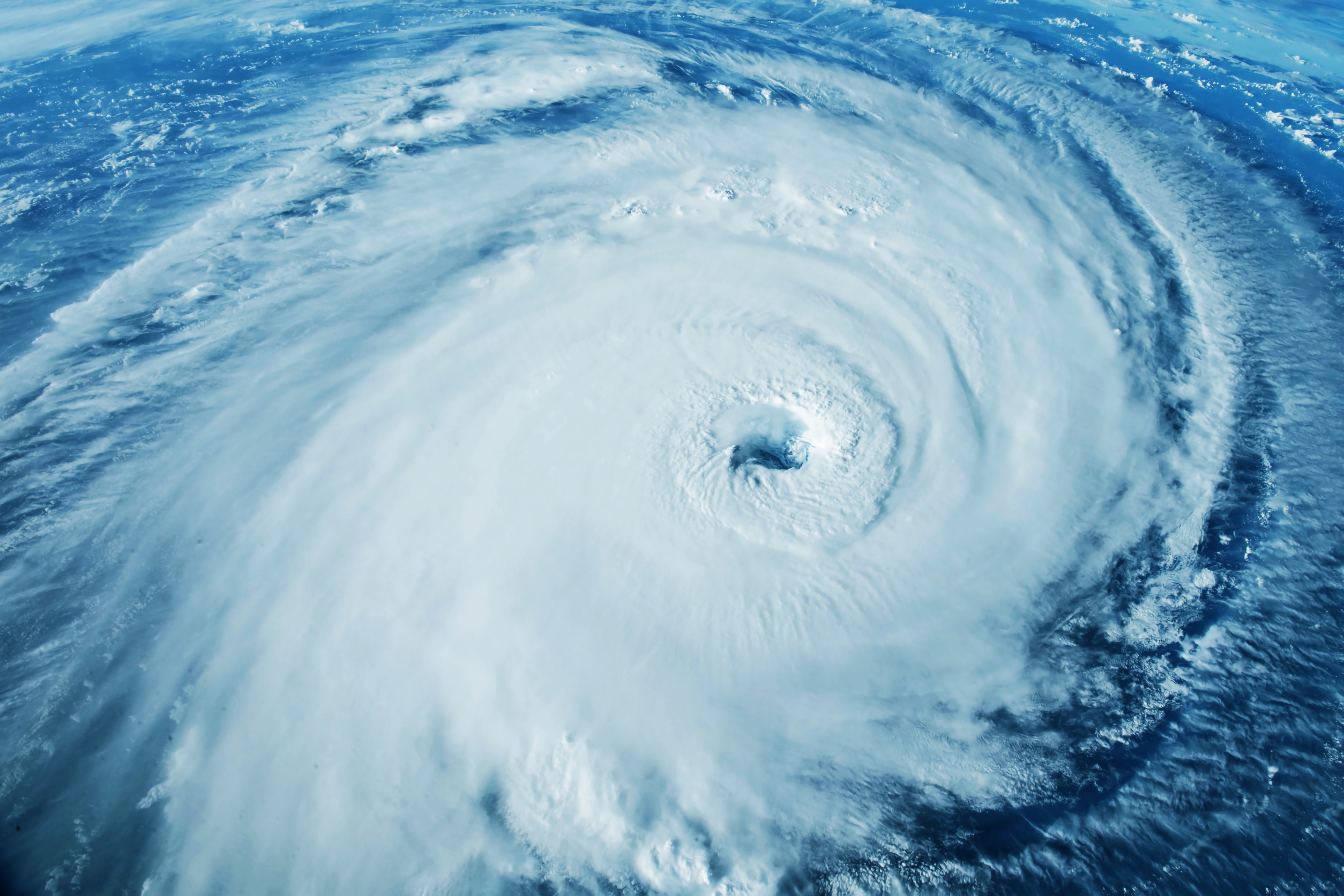
The upgrade of a 937 MB ( Ian) hurricane with a spot wind of 160 mph, meaning a cat 5. Having a cat 5 is laughable because of one post-analysis idea. It is giving ammo to climate change people who have no idea that total energy in these storms, as measured better by our POWER AND IMPACT SCALE, is not increasing. Idalia is a joke, too. When you can’t find sustained winds at a landfall point over 55 mph, you don’t have a major hurricane.
Let us review the power and impact scale and the idea behind it.
It uses Saffir Simpson pressure as a factor and 6-hour averaged recon winds. So Saffir Simpson is a foundation.
But, it also takes into account pressure tendency. A hurricane hitting the coast with rapid pressure falls in the last 12 hours will get its strongest winds to the surface. That should be intuitive since there must be a perfect alignment of the parameters needed to produce the storm intensity for that kind of rapid intensification. This means it is very hard to sustain that top wind. It is why calls for Cat 6 are an agenda-driven joke being pushed by people who are using Saffir Simpson to try to exaggerate how bad it is.
The classic was Florence. A major media outlet was opining that, when it reached the coast, it could be a cat 6. In reality, it was a 1 or 2.
If pressures are rising rapidly, as with Idalia, you subtract a category. The observations fit the hypothesis. If the pressure is essentially a steady state, the storm is in an equilibrium, and the standard ideas on wind can be used. The point is that in a rapidly deepening storm, winds can be almost 100% of flight level, and in a weakening storm, as low as 50%, as we saw with Idalia.
But a spot wind speed with all the reasons to adjust and constant data has left Saffir Simpson unusable in the face of history. Why? Because it does not take SIZE into account. Ian is the last storm I would want to downplay. Since nine days before I penned this, it was published on September 22nd. The hurricane hit the 28th-29th. I wrote it on the 20th.
https://www.cfact.org/2022/09/21/41023/
But Ian was no Donna. The size of Donna and the extent of strong winds were much greater.
The highest wind gusts in Miami Dade with Ian were, in most cases, under 50 mph.
Look at what happened in Donna.
In Miami, winds reached 97 mph (156 km/h).
So what we do is we measure the 2 greatest quadrants of 64 knots per hour (kt) winds, 50 kt winds, and 34 kt winds.
So, each of these is getting a factor. Think about how many extra parameters you have to evaluate the storm.
You have the Saffir Simpson factors of pressure and wind. So, we are using it as a base. (BTW, notice how Cat 5 hurricanes now have higher pressures than they used to? Another indication that they are much more compact. But, since the climate crowd wants to claim these are getting worse, then ALL STORMS NEED TO BE REANALYZED. They must take into account what we have been saying, that the size of the storm can tell us the total energy of the storm and if it is getting bigger. Fat chance that will happen since it will reveal they are not.
You have a pressure tendency in the last 12 hours. You have the radius of winds assigned values. For the mariners, we can also tack on the radius of the high seas. If we want to quantify it, a rainfall parameter has to be put in, but I think that should be a separate scale.
So you have a much more descriptive index of a storm; the more descriptive, the more objective the analysis.
For instance, Sandy was a major on my scale. Even though we had cat 1 winds on Saffir Simpson, its pressure was a strong cat 3. BUT THE SIZE OF THE WINDFIELD MADE IT THE REASON IT WAS SO STRONG. Hurricane-force winds extended out 200 miles from the center, and that kind of cumulative energy produces a greater build-up. Ike was a Major, and so was Gustav, for instance.
Here is something that drives home my point. Take Charley, 2004 at cat 4 at landfall. That storm was not nearly as widespread as Ian, a cat 4 at landfall. (I assume the 160 was not at landfall since peak gusts were around 140). But how about Donna? Hurricane winds are extending out 150 miles to the east. And what of the 1944 hurricane, which is a stand-alone storm as far as size? So, if we want to look at these things objectively, it is time to get rid of Saffir Simpson as it is now and simply use it as a base. It was a fine base, but interestingly enough, it is the climate change people who are pushing this message that things are getting worse and demand we upgrade all this so we can put all this in perspective.
So, let’s do this and see what is what.
Ida was no Betsy, for instance, though both were cat 4s.
Harvey was no Carla, though both cat 4s.
It works the other way, too, as there are storms that will be seen as greater if we get more descriptive.
Here is the other thing to remember. All these rapid, in-close deepeners since 2017 have occurred in phase 2 or 3 of the Madden Julian Oscillation. That makes sense, given that correlation. But every major long-tracked storm that has reached the US has hit weaker than its peak over the Atlantic! Unlike the 30s-50s, few storms that are majors more than two days away hit as majors. The exception to all this is Irma, who did cross the Keys as a major but once she made it to Naples, she was less.
I have been pushing for this since the hurricane season of 2008. It was Bill O’Reilly who put this in my head. I was doing a hit with him when Ike was coming, and they had lowered it to a cat 2, and he said, “So it’s not that bad”. (Not Bill’s fault; it’s just the perception based on a faulty scale.) That set me off, so that is what got me going on this power and impact idea. If we look at Wikipedia, we see Weatherbell.com is never included, yet we have been pioneering the impact forecasts since I got here. And I am sure that over the coming years, you will see that we are forced to change this scale because there is simply too much propaganda now associated with it as far as trying to make climate points. So, some good will come out of it.
By the way, for all the hullabaloo about the Atlantic, what about the lack of activity relative to averages in the number one Tropical cyclone basin on the planet, the Western Pacific? Surely, that has as much or more to do with climate observations since, on average, there is more bang for the buck.
One thing you can bet on is that we will never be mentioned. Look at it this way: It will be a windfall for hurricane researchers as they will have to go back and reanalyze all these storms. But I am sure it will never have the company’s name attached to it, as perhaps a seed for whatever idea they come up with. This is fine as long as it gets done so we get more objective and have a greater perspective.